• Home
  • Games
    Action-adventure Simulation Business Role Playing Sports Competition Casual Intelligence Card Strategy Music Rhythm Text Puzzle
  • Apps
    Business Office Newsletter Social Life Entertainment Online Shopping Practical Tools Travel Educational Learning Information Reading Sports and Health
  • Articles

English 中文(简体) 中文(繁体) 한국어 日本語 Português Español Русский العربية Indonesia Deutsch Français ภาษาไทย
Home Apps Travel Geo Survey
Geo Survey

Geo Survey

1
2
3
4
5
Download
  • Version 1.7
  • Category Travel
  • Package Name com.ncbc.survey.gis
  • Update Time April 12, 2025
  • Size 18.18MB
About this app

Geo Survey and data collection

Free application for carrying out GIS survey. This app enables surveyors to collect data (coordinates) of points on a map by creating polygons/poly-lines. This can be done in two ways. First, by walking around the area of interest, or secondly, through manual selection of an area on the map.

Features:

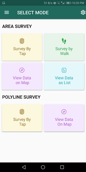
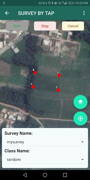
1. Survey can be carried out using any of the two modes:

a. First survey mode (walking mode) can be used by surveyors for collecting several points by walking around the field/land or any region of interest. Polygon will be drawn on the map once survey of field is stopped by the surveyor.

b. Second survey mode (manual selection) can be used by surveyors for collecting several points by tapping on the map. Polygon/poly-line will be drawn on the map once surveyor stops selecting points on the map.

2. Each polygon can be listed under main-category(survey) and subcategory(class) for better organization of survey data.

3. Each polygon can be titled/named separately by surveyor.

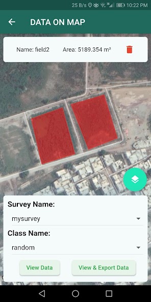
4. Data can be viewed by any of two choices:

a. View data on map - Polygons/poly-lines can be viewed on map by selecting a "survey" name and a "class" name.

b. View data without map - Data of polygons can be viewed without map if user does not want to plot polygons on map and only wants to view data of the polygons.

5. Export and Share - Export and share data in json format.

6. Limit Constraint - This free version of app has a limit constraint of creating 20 polygons/poly-lines for any "class" of any "survey". However, new "classes" can be creating for carrying out survey.

7. Cloud storage - Data is stored in and synced with cloud.

What's New in the Latest Version 1.7

Last updated on Feb 26, 2025 Minor updates
Download(18.18MB)
Users also viewed
  • King Cars & Couriers

    King Cars & Couriers

    23.00 November 10, 2025
  • ONTAP

    ONTAP

    2.1 November 9, 2025
  • Filipino phrasebook

    Filipino phrasebook

    2.8 November 9, 2025
  • EcoTravels

    EcoTravels

    6 November 9, 2025
  • TomTom LINK 100 Companion

    TomTom LINK 100 Companion

    1.1.0 (54) November 9, 2025
  • Bera Alanya (Bera Otel)

    Bera Alanya (Bera Otel)

    1.0 November 9, 2025
  • Skyguardian Tireguardian

    Skyguardian Tireguardian

    1.1.2 November 9, 2025
  • Miami Nights

    Miami Nights

    1.33.0.0 November 9, 2025
  • HafenCity Hamburg Guide

    HafenCity Hamburg Guide

    1.0 November 8, 2025
  • OBD Diag & Scan

    OBD Diag & Scan

    2.11 November 8, 2025
  • Wayper Transport&Offline Maps

    Wayper Transport&Offline Maps

    1.0.2 November 8, 2025
  • Easee

    Easee

    2.5.5 November 8, 2025
  • MOOG Parts

    MOOG Parts

    5.0 November 7, 2025
  • Uber Lite

    Uber Lite

    1.172.10001 November 7, 2025
  • Stadtplan Bonn

    Stadtplan Bonn

    1.1 November 7, 2025
About Privacy Policy Terms of Service Cooking Policy

© Copyright 2017-2025 downde.com