• Home
  • Games
    Action-adventure Simulation Business Role Playing Sports Competition Casual Intelligence Card Strategy Music Rhythm Text Puzzle
  • Apps
    Business Office Newsletter Social Life Entertainment Online Shopping Practical Tools Travel Educational Learning Information Reading Sports and Health
  • Articles

English 中文(简体) 中文(繁体) 한국어 日本語 Português Español Русский العربية Indonesia Deutsch Français ภาษาไทย
Home Apps Travel VesselFinder
VesselFinder

VesselFinder

1
2
3
4
5
Download
  • Version 5.7.8
  • Category Travel
  • Package Name com.astrapaging.vff
  • Update Time July 25, 2025
  • Size 50MB
About this app

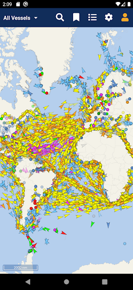
Real time AIS ship tracking of marine traffic, vessel database, ship photos.

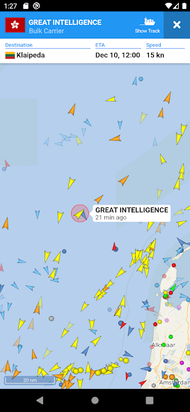
VesselFinder is the most popular vessel tracking app, providing real-time data on the positions and movements of vessels, utilising a large network of satellites and terrestrial AIS receivers.

VesselFinder features include:

- Real-time tracking of over 200,000 ships every day

- Ship search by Name, IMO number or MMSI number

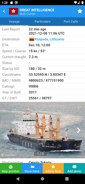
- Ship movements history

- Ship details - name, flag, type, IMO, MMSI, destination, ETA, draught, course, speed, gross tonnage, year of built, size and more

- Port search by Name or LOCODE

- Port Calls per ship – time of arrival and stay in ports

- Port Calls per port – detailed list of all vessels Expected, Arrivals, Departures and currently In Port

- My Fleet - add your favourite vessels to "My Fleet," synchronised with your VesselFinder account

- My Views - save your favourite map views for quick navigation

- Ship photos contributed by VesselFinder users

- Simple, Detailed, Dark and Satellite maps

- Weather layers (temperature, wind, waves)

- See Your Location feature

- Distance Measure tool

IMPORTANT:

If you experience any problem with the App, please fill this form to contact us http://www.VesselFinder.com/contact instead of writing a review here. We will do our best to solve it. Thanks!

Visibility of vessels in the App depends on AIS signal availability. If a particular vessel is out of our AIS coverage zone, VesselFinder displays her last reported position and updates it as soon as the vessel comes into range. Completeness and accuracy of the information provided cannot be guaranteed.

Connect with VesselFinder

- on Facebook: http://www.facebook.com/VesselFinder

- on Twitter http://www.twitter.com/VesselFinder

What's New in the Latest Version 5.7.8

Last updated on Oct 25, 2024 stability improvements
Download(50MB)
Users also viewed
  • ONTAP

    ONTAP

    2.1 November 9, 2025
  • Filipino phrasebook

    Filipino phrasebook

    2.8 November 9, 2025
  • EcoTravels

    EcoTravels

    6 November 9, 2025
  • TomTom LINK 100 Companion

    TomTom LINK 100 Companion

    1.1.0 (54) November 9, 2025
  • Bera Alanya (Bera Otel)

    Bera Alanya (Bera Otel)

    1.0 November 9, 2025
  • Skyguardian Tireguardian

    Skyguardian Tireguardian

    1.1.2 November 9, 2025
  • Miami Nights

    Miami Nights

    1.33.0.0 November 9, 2025
  • HafenCity Hamburg Guide

    HafenCity Hamburg Guide

    1.0 November 8, 2025
  • OBD Diag & Scan

    OBD Diag & Scan

    2.11 November 8, 2025
  • Wayper Transport&Offline Maps

    Wayper Transport&Offline Maps

    1.0.2 November 8, 2025
  • Easee

    Easee

    2.5.5 November 8, 2025
  • MOOG Parts

    MOOG Parts

    5.0 November 7, 2025
  • Uber Lite

    Uber Lite

    1.172.10001 November 7, 2025
  • Stadtplan Bonn

    Stadtplan Bonn

    1.1 November 7, 2025
  • English Chichewa Dictionary

    English Chichewa Dictionary

    22 November 6, 2025
About Privacy Policy Terms of Service Cooking Policy

© Copyright 2017-2025 downde.com