
Offline NZ Topo50 maps. Import & edit GPX, record hikes & find DOC huts, tracks
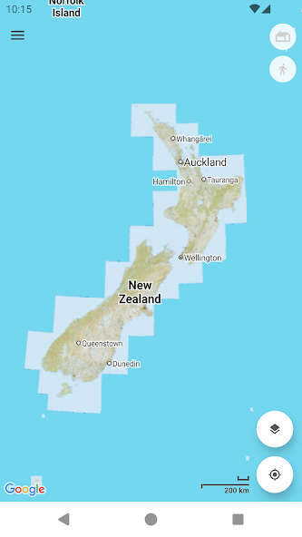
Topographic map of New Zealand with no limitations:
• View and cache topographic tiles and satellite imagery
• Download topographic tiles in a visible region and below (for offline availability)
• Add unlimited map markers
• Import GPX / KML / FIT waypoints, tracks and routes
• Plan, create and edit tracks with a powerful GPX editor
• Record routes or follow imported tracks
• Export and share tracks and markers
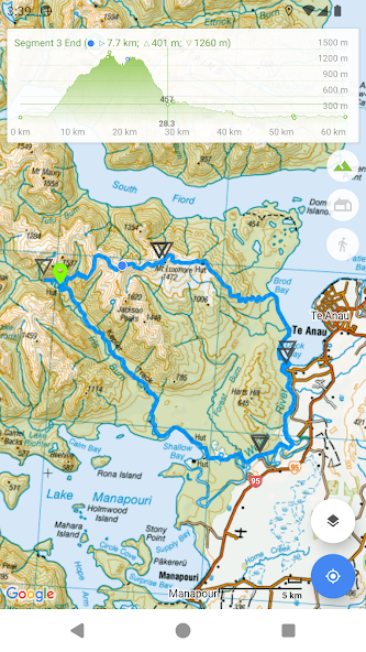
• View track / route elevation profile (with interactive graph)
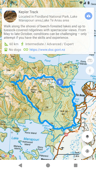
• Search and view DOC tracks (import tracks for offline availability)
• Search and view DOC huts and campsites (tap a hut marker for up-to-date information)
• Relief shading (giving the topography depth)
• Measure distance (in a straight line) between multiple points and markers
• Search for places of interest (supports Decimal, DMS, NZTM2000 and UTM coordinates)
• Topographic imagery for Antipodes, Auckland, Bounty, Campbell, Chatham, Kermadec and Snares Islands
• Paper map reference (Topo50 sheet index) for markers (when viewing NZTM2000 coordinates)
• Group markers by tag for easy organisation (change colours, toggle visibility)
• Battery conscious (for those that can't recharge every day)
• Space conscious (for those that don't have gigabytes to spare; external SD card support; full tile cache control)
• Stay up-to-date with the latest imagery (no dependency on application updates)
• Navigate with Google Maps interactions (pinch zoom, scroll, rotate, drop marker, drag marker etc)
• Fully functional for free!
New Zealand (NZ) Topo Map is intended for outdoor enthusiasts who want to mark locations visited, create markers to visit, follow imported tracks or create their own. It's designed to be lightweight, intuitive, responsive, battery conscious and totally free.
This app is perfect for tramping, hiking, walking, biking, mountain biking, running, hunting and any outdoor activity that requires topographic and satellite imagery available offline. Integrated with DOC (Department of Conservation) you can get the latest hut, campsite and track information.
Developed by an adventurous Kiwi for adventurous Kiwis!
Topographic Map Tiles
The Topo50 map series provides topographic mapping for the New Zealand mainland and Chatham Islands at 1:50,000 scale.
At a scale of 1:50,000, Topo50 maps show geographic features in detail. They are useful for a wide range of activities such as local navigation by vehicle or on foot, locality area planning and study of the environment. Used by a wide variety of groups, Topo50 is the official topographic map series used by New Zealand emergency services.
To produce our Topo50 maps of the New Zealand mainland we use:
• The New Zealand Geodetic Datum 2000 (NZGD2000) – the coordinates of longitude and latitude
• The New Zealand Transverse Mercator 2000 (NZTM2000) projection – this is what enables the curved mathematical surface approximating the Earth to be represented on a flat sheet of paper.
To produce our Topo50 maps of the Chatham Islands we use the Chatham Islands Transverse Mercator 2000 (CITM2000) projection.
Topo50 map tiles sourced from the LINZ Data Service http://data.linz.govt.nz/ and licensed by LINZ for re-use under the Creative Commons Attribution 3.0 New Zealand licence.
Satellite Imagery
LINZ has been working towards getting New Zealand’s most current publicly-owned aerial imagery – covering 95% of the country.
Aerial imagery is captured from airborne sensors and cameras. It provides an accurate photographic representation of the earth’s surface and the features on it. It can be used to visualise landscape, or to understand how an area has evolved over time.
Sourced from the LINZ Data Service and licensed for re-use under the Creative Commons Attribution 3.0 New Zealand licence (http://www.linz.govt.nz/data/licensing-and-using-data/attributing-aerial-imagery-data)
 Download